Flood levels of the Hawkesbury River recorded at Windsor Bridge, floods 9.15 metres (30 ft) and over. Major floods shown in bold.
| Year | Month | Height (m) | Height (ft&ins) |
| 1799 | March | 15.25 | 50′ |
| 1800 | March | 12.2 | 40′ |
| 1806 | March | 14.64 | 48′ |
| 1806 | August | 14.33 | 47′ |
| 1806 | October | 9.15 | 30′ |
| 1809 | May | 14.64 | 48′ |
| 1809 | August | 14.49 | 47′ 6″ |
| 1816 | June | 13.88 | 45′ 6″ |
| 1817 | February | 14.03 | 46′ |
| 1819 | February | 14.03 | 46′ |
| 1819 | June | 14.03 | 46′ |
| 1857 | July | 9.91 | 32′ 6″ |
| 1857 | August | 11.44 | 37′ 6″ |
| 1860 | April | 11.21 | 36′ 9″ |
| 1860 | July | 10.45 | 34′ 3″ |
| 1860 | November | 10.98 | 36′ |
| 1864 | June | 9.91 | 37′ 6″ |
| 1864 | July | 10.98 | 36′ |
| 1867 | June | 19.26 | 63′ 2″ |
| 1869 | May | 11.21 | 36′ 9″ |
| 1870 | April | 13.72 | 45′ |
| 1870 | May | 10.83 | 35′ 6″ |
| 1871 | May | 11.21 | 36′ 9″ |
| 1873 | February | 12.66 | 41′ 6″ |
| 1875 | June | 11.82 | 38′ 9″ |
| 1877 | May | 9.15 | 30′ |
| 1879 | September | 10.52 | 34′ 6″ |
| 1879 | September | 13.91 | 43′ 3″ |
| 1889 | May | 11.74 | 38′ 6″ |
| 1890 | March | 12.12 | 39′ 9″ |
| 1890 | March | 10.52 | 34′ 6″ |
| 1891 | June | 10.83 | 35′ 6″ |
| 1894 | March | 9.68 | 31′ 9″ |
| 1895 | January | 9.3 | 30′ 6″ |
| 1898 | February | 9.61 | 31’6″ |
| 1900 | July | 14.08 | 46′ 2″ |
| 1904 | July | 12.22 | 40′ 1″ |
| 1916 | October | 10.83 | 35′ 6″ |
| 1922 | July | 9.45 | 31′ |
| 1925 | June | 11.36 | 37′ 3″ |
| 1934 | February | 9.15 | 30′ |
| 1943 | May | 10.11 | 33′ 2″ |
| 1949 | June | 11.97 | 39′ 3″ |
| 1950 | March | 9.2 | 30′ 2″ |
| 1950 | April | 9.2 | 30′ 2″ |
| 1950 | June | 9.45 | 31′ |
| 1952 | June | 9.35 | 30′ 8″ |
| 1952 | June | 11.61 | 38′ 1″ |
| 1952 | August | 9.71 | 31′ 10″ |
| 1955 | May | 9.76 | 32′ |
| 1956 | February | 13.7 | 44′ 11″ |
| 1956 | February | 11.56 | 37′ 11″ |
| 1956 | March | 9.81 | 32′ 2″ |
| 1956 | June | 9.53 | 31′ 3″ |
| 1961 | November | 15.1 | 49′ 6″ |
| 1963 | New gauge reduced by 305mm | ||
| 1964 | June | 14.51 | 47′ 7″ |
| 1969 | November | 10.06 | 33′ |
| 1974 | May | 10.28 | 33′ 9″ |
| 1978 | March | 14.31 | 46′ 11″ |
| 1978 | June | 9.55 | 31′ 4″ |
| 1986 | August | 11.3 | 37′ 6″ |
| 1988 | April | 12.65 | 41′ 6″ |
| 1988 | July | 10.74 | 35′ 3″ |
| 1990 | April | 9.8 | 32′ 2″ |
| 1992 | February | 11 | 36′ 1″ |
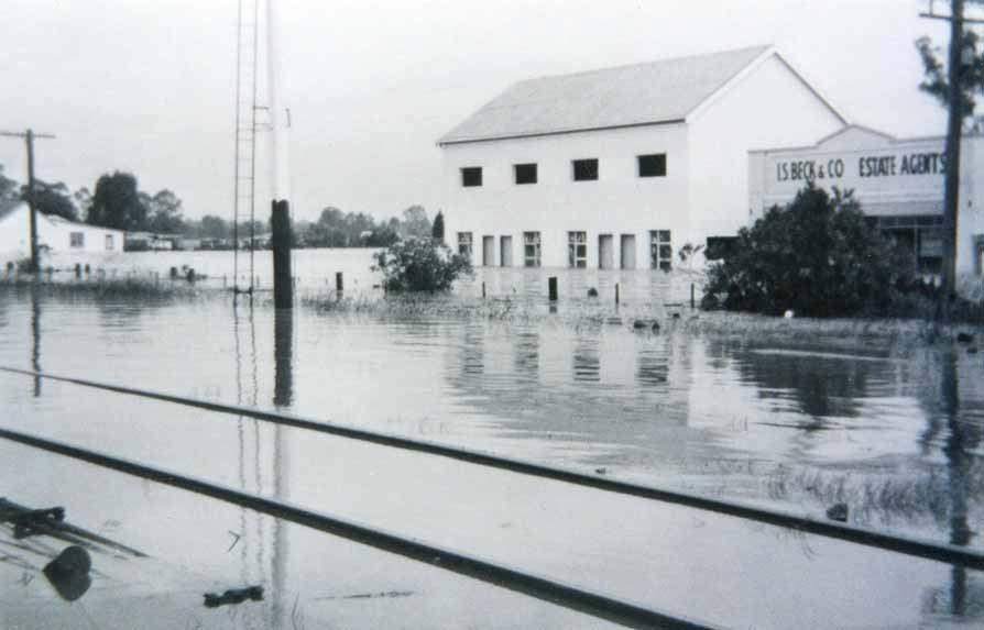
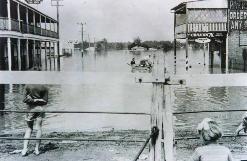
Flood types and effects:
- MINOR – From about 5.8 m
Causes inconvenience, minor roads & low-level bridges affected. - MODERATE – From about 6.9m
Overbank flow occurs with damage to low lying homes and farms. North Richmond bridge closes at 8.4m and Windsor Bridge at 6-9m. - MAJOR – From about 12.2m
Widespread inundation. Large areas flooded, towns & properties isolated & waters encroach. Extensive damage and hardship can occur.
Source: Flood Levels from Hawkesbury Gazette, Sydney Gazette & Macquarie Country. Description from Civic News August 1988, p. 9, inserted in the Hawkesbury Gazette 1988.

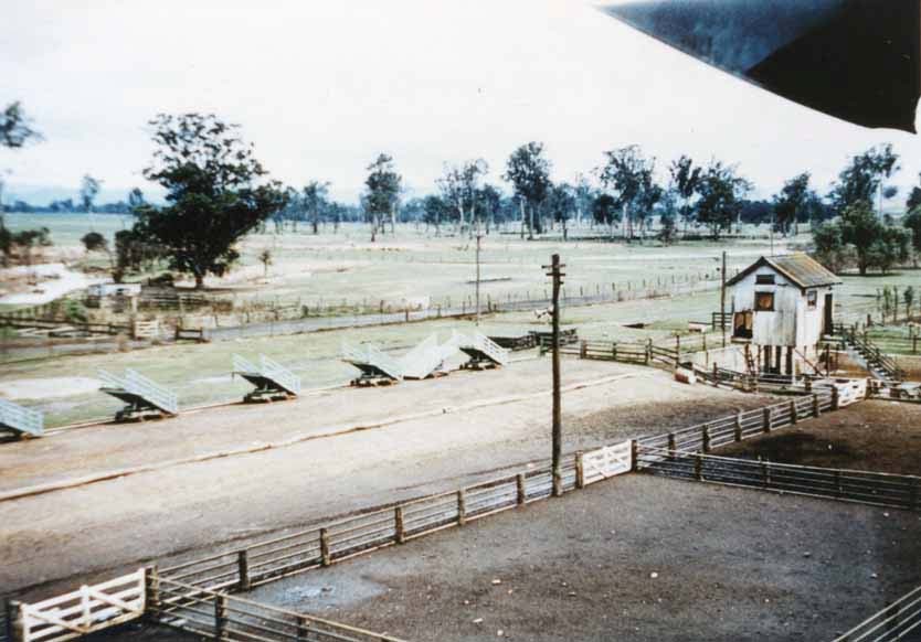
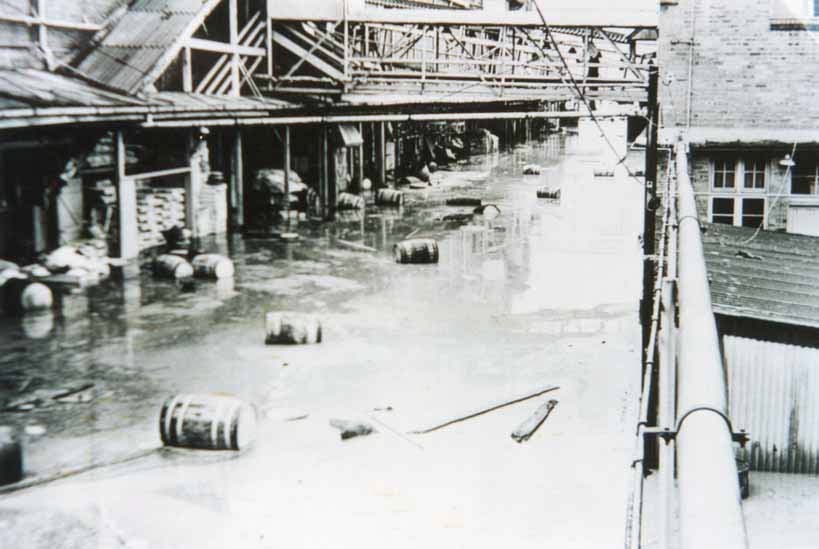
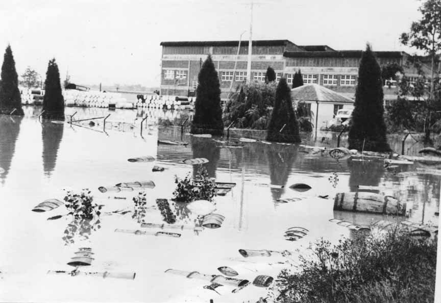
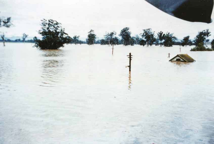 1961 Flood before (below) and after (above) photos (6 weeks apart) taken from the top of the old skin sheds looking over the stables behind the Riverstone Meatworks.
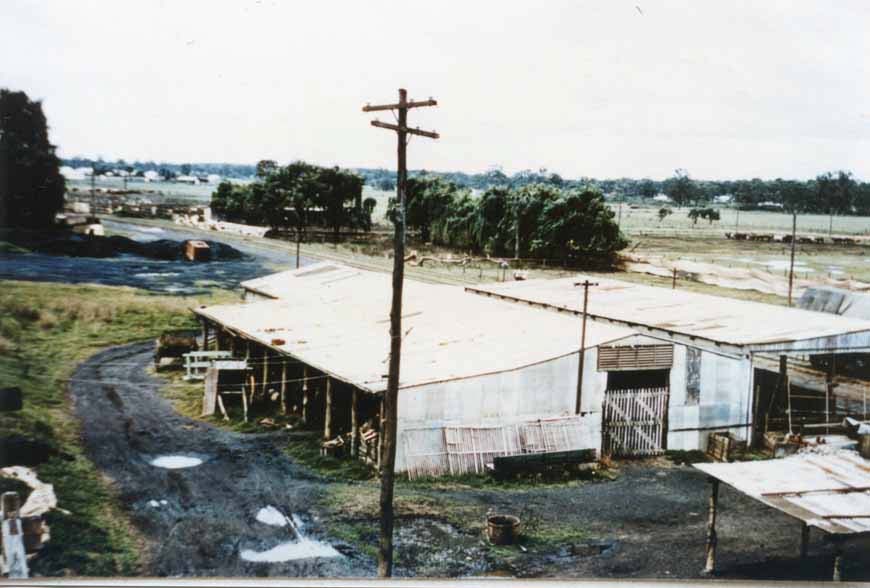
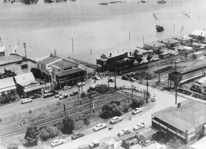
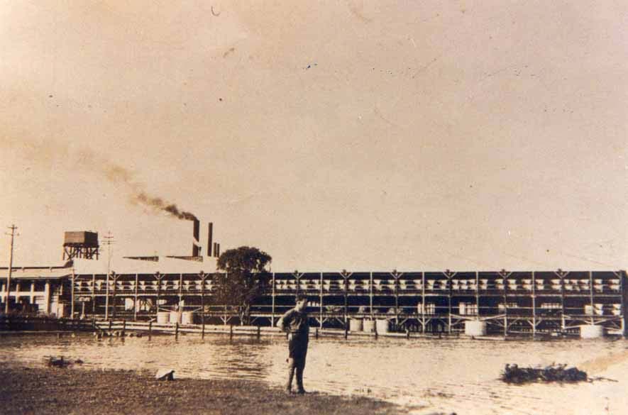
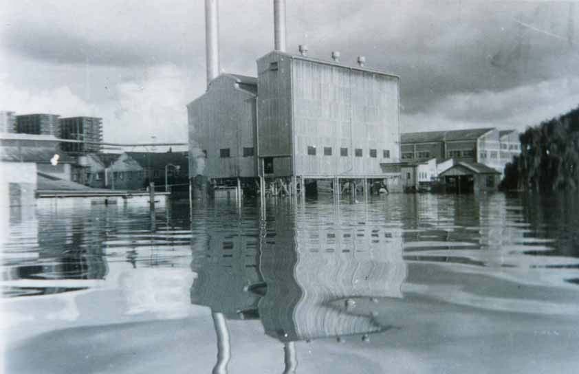
[courtesy of B. Allison].