by Clarrie Neal
The first land grant in the district comprised 2,500 acres and was known as ‘Riverston’. ‘Grantham Farm’ was the name later given to the first part of the ‘Riverston’ estate to be developed and could well be described as the birthplace of Riverstone.
Governor Phillip on an early expedition to the Hawkesbury area in 1791 had described the area around Eastern Creek as – the face of the country was of poor soil, but freely formed and covered with stately white gum trees.
In 1802 Governor King declared the entire Riverstone – Schofields area as a stock reserve, to be used only as common grazing land. Governor Macquarie, who arrived in 1809, decided to make better use of these lands by giving land grants to the early settlers for farming to help feed the struggling colony.
In December 1809, Maurice O’Connell arrived in Sydney as Commander of the 73rd Regiment and in 1810 was made Lieutenant-Governor of the colony. Later that year when he married Mary Putland, the widowed daughter of Governor Bligh, he was granted an area of 2,500 acres by Governor Macquarie as a wedding present. The boundaries today would be Eastern Creek, Bandon Road, Windsor Road, and Garfield Road. O’Connell named the estate ‘Riverston’ after his birthplace in Ireland and was supplied with six convicts to clear and operate the farm.
Another 1,000 acres known as ‘Macquarie Mount’ was granted to O’Connell in 1814, extending the estate’s southern boundary to Kensington Park Road. When he was transferred to India with his Regiment in 1814 he left the farm in the care of a George Druitt.
Records from Governor Macquarie’s journals show that on the 8th December 1810, returning from a visit to the Windsor farms, he made a short stop at the ‘Riverston’ estate. The journal reads- We halted for about a quarter of an hour at Lt. Col. O’Connell’s farm at Riverston, (granted to him by me on his marriage) distant about six miles from Windsor on the high road to Parramatta, examined his dairy and stockyards, and then pursued our journey.
The 1822 muster shows six convicts assigned to Col. O’Connell at Windsor. However, the Post Office Directories of 1832 and 1835 for the Windsor Road show only the names of farms owned by Rouse (Vinegar Hill) and Terry (Box Hill); there is no mention of ‘Riverston’ farm. The census of 1841 shows no residents on the property, but noted capital improvements including “a completed timber house and another partially completed”. This indicates there may have been more than one cottage on the estate. From 1839 to 1847 the property was mortgaged to John Terry, a neighbour.
Most of the estate appears to have been used for stock grazing only, with the development of vineyards on the slopes of Eastern Creek. Thomas Musgrave’s map of the Windsor district in c.1842 shows a cleared area and fenced paddocks with buildings on the site. The map shows a track leading west from the Windsor Road to the ‘Riverston’ farm houses and another track leading to the vineyards on Eastern Creek.
O’Connell first advertised the estate for sale on the 27th March, 1845 in the Sydney Morning Herald; it was eventually sold in 1847 to the Australian Trust Co. who in turn sold it to Andrew H. McCulloch, a Sydney solicitor, in 1855.
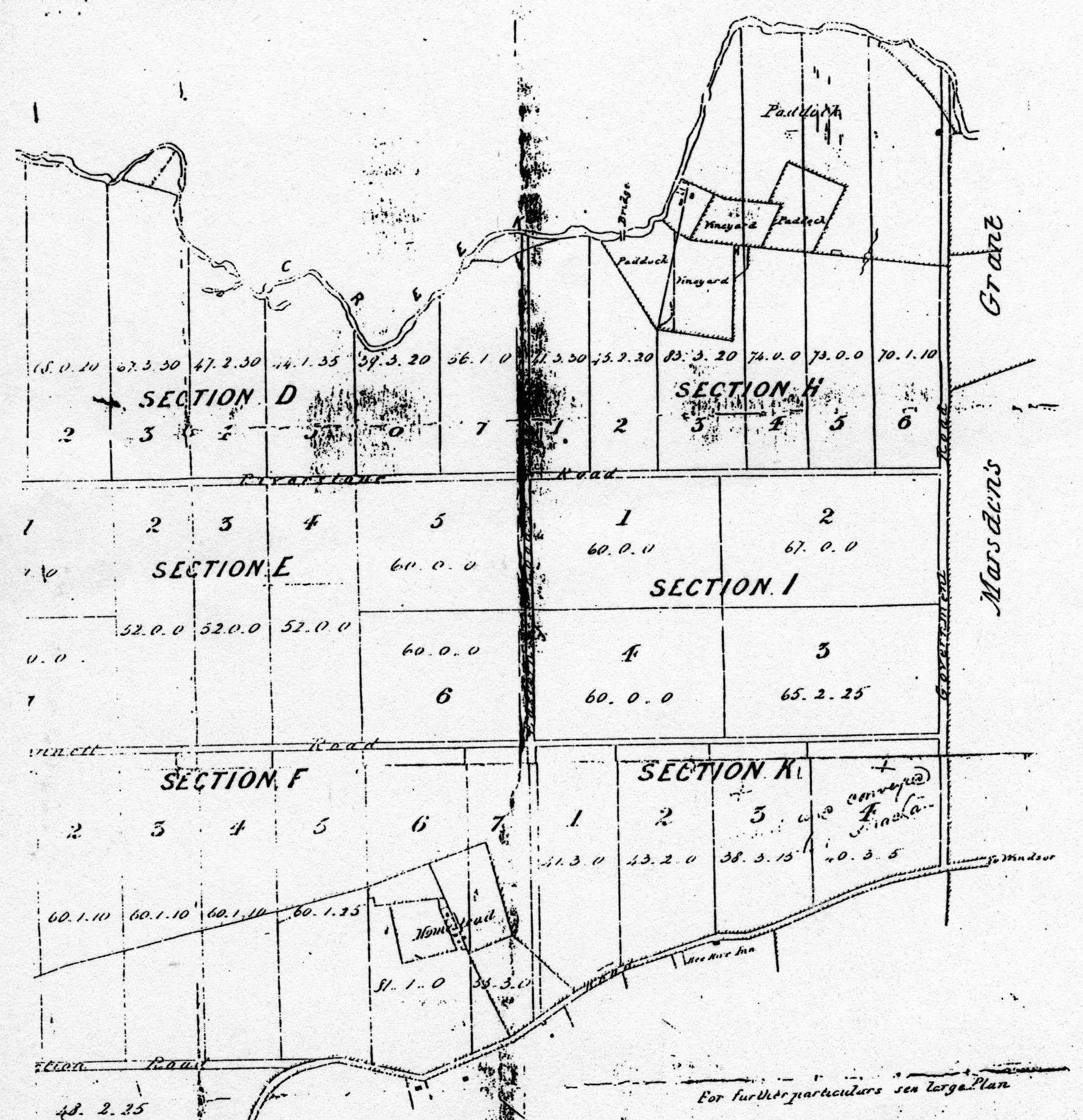
McCulloch immediately subdivided the whole estate into eight sections, with 59 farms for sale. The Sydney paper The Empire on 24 April 1856, advertising the auction, described the actual ‘Riverston’ homestead blocks as -Section ‘F’, Lot 6, contains 81 acres, with dwelling house, outbuildings, well of water, enclosed paddocks, stockyard, good cultivation ground and a fair supply of timber. The lot is known as the Riverston Homestead. Lot 7 is another portion of the Homestead, containing 55 acres. There are two cleared paddocks of good soil, with frontage to the Windsor Road.
It appears the ‘poor soil’ as described in 1791 by Governor Phillip must have improved dramatically as other parts of the estate when auctioned in 1856 were advertised as ‘good cultivated land’, ‘splendid agriculture land’, ‘excellent grazing land’, and ‘well timbered’.
Despite the agents ‘optimistic’ descriptions of the estate, the 1856 sale was unsuccessful, and when auctioned in 1864 with the opening of the rail line, McCulloch again suffered the same disappointing result. In the meantime three of the larger blocks were sold – 179 acres to a Mr. Dawson, 179 acres to William Rumery and 79 acres to James Strachan, whose family became the keepers of the Bee Hive Inn on the Windsor Road at Vineyard. These three blocks were not part of the Grantham estate.
These sub-divisions of the 1850’s and 80’s of the ‘Riverston’ estate established the present day road pattern of the Riverstone district. Many of these roads, particularly those of the Vineyard area are still non existent, and appear only as names on a map.
With the development of Riverstone in 1878, McCulloch then offered one and two acre blocks for sale in the first township subdivision of the area bounded by the rail line, Crown Road, Piccadilly Street, and Robinson Street. By this time Benjamin Richards had purchased his 2,500 acres of land on the western side of the rail line for his meat works.
In May 1881, the larger ‘Riverston’ estate was again subdivided into smaller farms and offered for sale by auction. As Riverstone developed with the expansion of the meat works, more auction sales were held with various portions of the original ‘Riverston’ estate now being identified by different names -Riverstone estate 17th September 1881, was the 2nd auction held that year. Roseberry Park estate 1st March, 1884, Riverstone Heights estate c 1886, Grantham Estate c1886.
When the area failed to sell as farms, some of the estates were subdivided into ridiculously small lots measuring 30 ft x 200 ft. As one would expect with the poor soil so characteristic of the area, all these schemes attracted little interest from the buyers.
This last auction shows Grantham Farm surrounded by the properties being auctioned with the Grantham Estate bounded by Crown Road, Windsor Road, Victoria Street and Brisbane Road. The farm itself, now reduced from 81 acres to 39 acres, is bounded by Princes Street, Grantham Street, and Loftus Street, and is the only cleared area on the estate.
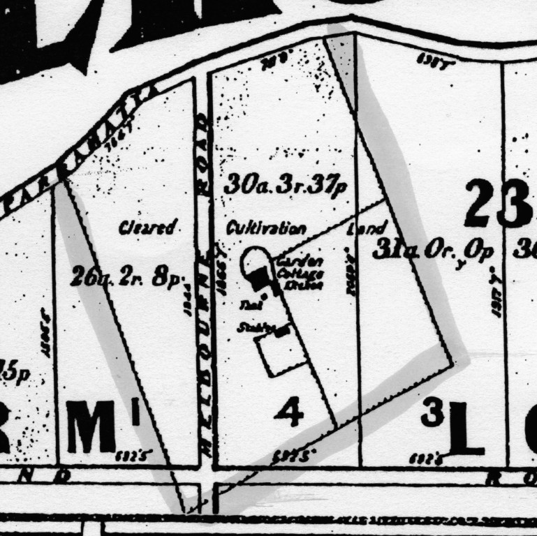
This appears to be the first official use of the name ‘Grantham’, but it is not known exactly when and where the name originated. The plan clearly shows the location of the original buildings that may have been the dairy and the accommodation built for the overseer and convicts on the original ‘Riverston’ estate.
Land Titles Office records show that an area of 39 acres known as ‘Grantham Farm’ was sold as part of the ‘Riverston’ estate in 1886 to Julius Schoffel for the sum of 775 pounds. This was an extraordinary amount of money for those days and it indicates the farm was well developed with substantial buildings. The farm is bounded by Loftus Street, Grantham Street, Princes Street, and the western boundary is the area used as a gravel pit in the 1930’s and 40’s.
Julius Schoffel operated the farm from 1886 until his death in 1906, when it was taken over by his brother Thomas, with records showing orchardists Thomas and Alfred Rumery as the owners/mortgagers. In the mid 1920’s Sam Challenger took over the property.
The property was sold to the Swift family in 1933 who built a new house on the hill on the Princes Street corner near the gravel pit. They continued to operate the farm, running a small dairy and had a few fruit trees. A drain two feet deep was dug along the gravel pit boundary, possibly to prevent any run-off onto the farm. The covered pick-up stand for the milk cans was located near the bottom entry gate in Grantham Street. To supplement the family income Lionel Swift also worked in the hide house at the meat works.
Ken Schoffel (b.1928) recalled returning to Riverstone just after the death of his mother, moving into his grandmother’s home on the Windsor Road. As a lad he spent a lot of his time on Swift’s farm, helping Lionel with the farm work. He found the Swift’s a caring family, also called Mrs. Swift ‘Nan’ and remembers her as a wonderful lady who always made sure he had good meals. He said he often refused to accept money for doing work around the farm.
He recalled:
-
- milking the cows. There were about 30 in the herd and when feed was scarce, letting the cows out into the nearby bush to graze .
- the cans being loaded onto the truck and taken to the milk factory at Windsor.
- using the chaff cutter.
- planting crops such as corn and oats.
- Lionel’s large gold fish pond at the back of the new house. Walking to Vineyard school with Lionel’s step sisters – Rosie and Cecily Smith.
- Roy Challenger (Wilma’s father) working on the farm.
During the interview, when first shown the old photo of the Schoffel farm, Ken said it was definitely not Grantham Farm, but was not so certain later in the interview.
In the late 1950’s Lionel Swift entered into a partnership with Noel Vickery Dunston to grow mushrooms in sheds on the property. With the untimely death of Lionel and then his mother, the property was taken over by Noel Dunston in 1963.
Noel built stables for his trotters and built a training track around the adjacent gravel pit to train them, the track being used by several other Riverstone trainers when their track on Garfield Road was closed. Noel also built the large dam that exists on the property today.
Noel’s wife Jean recalled the fruit trees, the slab barn and the old house in the lower paddock of the property that was let to the Hunt family for many years. When the Hunt family moved to Perth Street the old buildings were demolished. The nearby well, full of goldfish, was considered too dangerous for their younger children so they had it filled in.
Colin Cubitt, who as a child in the 1930’s lived nearby in Loftus Street and later in the 1960’s worked several years with Noel Dunston on the mushrooms, recalled –
-
- as a child playing in the trench that bordered the gravel pit and Swift’s property.
- the milk can stand with a galvanised iron roof in Grantham Street, still there in the 1950’s.
- the well and its goldfish near the original barn. The well was square shaped with natural earth sides, with a water level two to three feet below ground level that remained static. The water was always clear but it was not used as the city water had been laid on to the farm in the late 1930’s.
Johnny Hunt, whose family came from Tenterfield in the late 1940’s and were the last family to live in the old homestead recalled –
-
- the family renting an old home from Swifts, situated about 100 yards in from the Grantham Street gate entrance.
- the house in two parts, both with cement floors, the bedrooms were next to the barn, and the kitchen, laundry and bathroom in a separate building 50 to 60 feet away, they had to walk across the grass to get to the kitchen for breakfast.
- the barn, a double storey slab building, with a hoist on the end facing Princes Street.
- Going up the driveway and located on the right hand side, and in front of the barn was the well. It was sited about 20 yards from the bedrooms. Today (2002) there is a slight depression in the ground here that may indicate the exact site.
- the well was not connected to the house or the barn. He said geographically the well was located on the high ground, so it may have been fed from a spring; the well was full of goldfish, that he used to catch and sell.- The stand of bamboo at the side of Swifts house, still thriving today (2002).
- The family buying vegies from Mr. Bull who lived opposite the Grantham Street gate.
John has since contacted other family members and all have confirmed the above details. Some family members recalled discussions with Lionel Swift where he stated that their kitchen building may have been previously used for other purposes. Contour maps issued in 1957 show the farm houses exactly as John described them, with Swift’s residence and sheds also shown at the top of the hill near the old gravel pit.
John later confirmed that the well was square shaped, the rim formed of large 9” x 4” beams to prevent the top soil collapsing. He also confirmed that at the end of the barn under the hoist, continuous use had left a large depression in the ground.
Aerial photos taken in 1968 show the house and several sheds adjacent to the gravel pit boundary, a total of four dams, and a single building (the old barn) near the old well site. Aerial photos in 1997 show the farm being extensively used with a number of metal and PVC green houses.
Other items of interest:
-
- the bell that was used on Grantham Farm to summon the convicts to start and finish work is now located at St Paul’s Church of England church at Riverstone.
- the Windsor & Richmond Gazette of 13 November 1918 noted – A bush fire on Grantham Estate. The scrub burnt fiercely and made rapid headway, fanned by a heavy wind. It was providential that some of the houses in the vicinity were not destroyed or damaged.
- In the 1940’s Loftus Street was partially formed to take a line of power poles out to the Windsor Road. The greyhound men of the day (and there were many) had a better use for this 300 – 400 yard straight stretch of track and used it as a training track for their dogs. A modified bike frame with a single wheel was used to drag the stuffed lure up the hill for the dogs to chase.
- A large blackberry bush growing on the creek side of Loftus Street marked the site used by the horse drawn sanitary carts for the townships’ first sanitary depot. The blackberry bush was a haven for rabbits, sometimes causing the greyhounds being trialled up the straight to make a comical detour.
- World War 2 when several hundred soldiers camped near Loftus Street for several days.
- Noel Dunston sold the property in the 1980’s to an English family and it became known as the Ellawong Estate, it was then leased to a Mr. Thornton. The present owner is Sam Camilleri with the property being used for grazing and green house farming.
- the term gravel pit was a misnomer as it was actually a hill of gravel, the top 2-3 feet being scraped off and used on the roads of Riverstone. The gravel has a characteristic red colour. Another similar gravel pit was located on the Bandon Road corner at Vineyard station.
- the house built by the Swift family in the 1930’s was demolished after it was damaged by fire in c.1995.
- In the 1950’s Bert Logan had an orchard in Princes Street on a lot that had the appearance of a gravel pit. Bert had the soil tested, made up the deficiencies and grew the best tasting navel oranges.
Information from descendants of Karl Schoffel’s family indicates that the original Grantham homestead was burnt down in the early 1900’s. In an article written by Pamela Hinchliffe on her father, Reg Schoffel’s childhood, states in part:
My father remembered when they used to stomp on the grapes in the vats to make wine. It was most likely at Grantham Farm as they would make their own wine each season.
He often mentioned that the farmhouse at Grantham Farm had burnt down, this was most likely the original old house that stood in the middle of the property. This event was perhaps one of the more traumatic happenings of his life, as you can imagine watching your home burning to the ground. An event he spoke about into his later years.
The family of Pearl Douglass (Reg Schoffel’s half sister) also recall her saying the house was burnt down in the early 1900’s.
Was the well located on a spring, which in the early 1800’s made it an ideal site to build a cottage nearby? Or maybe the well was fed from the roof water of the original buildings, which explains why it is located on the higher ground.
At this point we cannot claim that the buildings in Schoffel’s photo are those of Grantham Farm, nor can we ignore the fact that the Schoffel family operated the farm from 1886 to 1933. Hopefully, someday, more family research may provide the answer.
However, members of the Historical Society are satisfied to have located the well site, and believe that the farm site is the birthplace of Riverstone.
Compiled by Clarrie Neal from information and photos provided by the Schoffel family, Colin Cubitt, Merv Davis, Johnny Hunt, Rosemary Phillis, Florence Short, and Tommy Henderson. September 2002 and March 2003.